How to get there
 Drohobycz (Drogobycz), Boryslaw and the neighboring villages and towns are located north-east of the Carpathian mountains, approximately 75 miles (120 kilometers) southeast of the provincial and regional capital of Lwow (Lviv) in present day Ukraine. The Tys'mienica (Tys'menytsa) River runs through both towns, which are situated approximately 6 miles (9 kilometers) apart. The scenery and the climate in the entire area are affected by its proximity to the mountains.
Contents
The geography of Drohobycz
The geography of Schodnica and the neighboring towns and villages
The western Ukraine is known geographically as Prikarpatye or Podkarpatye (literally: near the Carpathian Mountains, or the Carpathian foothills).
THE GEOGRAPHY OF DROHOBYCZ
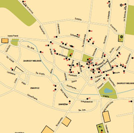
Drohobycz (in Polish) or Drogobycz (in Ukrainian) is located in western Ukraine and serves as an administrative center in the Lviv (Lwow, in Polish) Oblast (Province). The town is located at the foot of the central Carpathian mountains separating the Ukraine, south east Poland and Romania. Drohobycz is surrounded by forests and villages. The Tys'menytsia River (a tributary of the Dniester/Dniestr) and its tributary, the Seret River, run through town. The area is rich in salt deposits and was one of the Ukraine's richest petroleum and ozokerite (mineral wax) areas.THE GEOGRAPHY OF BORYSLAW
Boryslaw is located 5.9 miles (9.6 kilometers) southwest of Drohobycz (Drogobycz), in a valley carved by the Tys'mienica (Tys'mienytsa) River and its three tributaries, called by the local population the Ponerlanka, Ropianka and Potok. The area is particularly rich in petroleum and ozokerite deposits and mineral springs. Boryslaw is separated from neighboring oil towns like Schodnica (Skhidnytsia) by the High Beskyd Range (Tsukhovyi Dil), which rises to approximately 3100 ft (942 meters). Boryslaw itself is about 1200ft (343 meters) above sea level. From the west, the town is framed by evergreen forests of the eastern branch of the Carpathian Mountain chain covered by on the Upper Beskyd Range (Tsukhovyi Dil.).
These forests played an important role in the survival of many of our families during the Holocaust.
THE GEOGRAPHY OF SCHODNICA AND NEIGHBORING TOWNS AND VILLAGES
Schodnica (Polish) or Skhidnycia (Ukrainian) is located approximately 6.5 miles (10 kilometers) South-Southwest of Boryslaw. Built on a hillside, the town ranges between 2000 ft (600 meters) and 3000 ft (9000 meters) above sea level and is known as a ski area. Schodnica is separated from Boryslaw by the Upper Beskyd Range (Tsukhovyi Dil), which rises to about 3100 ft (942 meters).Getting There
The closest airports are Lviv (LWO) or Kiev (KBP)
- Surrounding towns and villages
- An interesting and useful site including information on Roots Trips
- Download of Drohobycz interactive map
- List of Jewish towns and villages in the vicinity of Drohobycz and BoryslawJewish Heritage